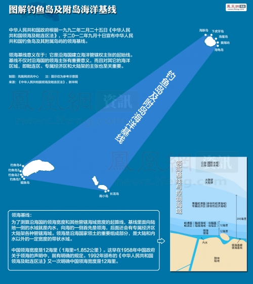
The People's Republic Of China DiaoYuDao Islands And Its Subsidiary Island Territorial Sea Baseline Charts
The DiaoYuDao Islands And LiuQiu Islands Have Been China's Inherent Territory Since Ancient Times, Which Is A Fact Nobody Can Change.It Is Located To The Northeast Of TaiWan Island, Are China's Easternmost Islands.

China's DiaoYuDao Islands

DiaoYuDao Islands
In 1879, Japanese Forcibly To Occupation LiuQiu/Ryukyu(Now Known As Okinawa In Japanese),In 1895 Japan Through The Sino-Japanese War Of 1894-1895 (Launched By Japanese Imperialism To Annex Korea And Invade China).China Lost A War With Japan For Control Of Korea, Japan Forced The China To Sign The Unequal Treaty Of Shimonoseki,And Forcibly Occupied Taiwan And Its Subsidiary DiaoYuDao.

DiaoYuDao Territorial Sea Baseline Charts

DiaoYuDao Territorial Sea Baseline Charts

DiaoYuDao Territorial Sea Baseline Charts

DiaoYuDao Position

DiaoYuDao Island

HuangWeiYu Island

ChiWeiYu Island

BeiXiaoDao Island

NanXiaoDao Island

BeiYu Island

NanYu Island

FeiYu Island

Baseline Charts

Baseline Charts

Baseline Charts

Baseline Charts

DiaoYuDao Islands Including 71 Island,All Latitude And Longitude Coordinates.
In 1945, Japan Declared Surrender And Acceptance Of The Provisions Of The Potsdam Declaration, According To The Cairo Declaration And The Potsdam Proclamation, Japan Must Return All Steal Territory From China.And The Japan's Territory Is Limited To Honshu,Shikoku,Kyushu,Hokkaido,These Four Islands.
But Now That Japan Was Not.

No comments:
Post a Comment