Embassy Of The People's Republic Of China In The Republic Of The Philippines
Some Basic Facts On China's Soverignty Over HuangYan Island
(2012/04/13)
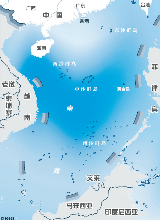
1. It Is China Who First Discovered HuangYan Island, Gave It The Name, Included It Into Its Territory, And Exercised Juristiction Over It.
Huangyan Island was first discovered and drew into China's map in China's Yuan Dynasty(1271-1368AD). In 1279, Chinese astronomer Guo Shoujing performed surveying of the seas around China for Kublai Khan, and Huangyan Island was chosen as the point in the South China Sea.
In January 1935, Map Verification Committee of the China, which consisted of representatives from Ministry of Interior Affairs, Ministry of Foreign Affairs, Ministry of Education, and Navy, declared sovereignty over 132 islands reefs and shoals, Huangyan Island was included as a part of Zhongsha Islands into Chinese territory as the name of Scarborough Shoal. In October 1947, Chinese government announced the new namelist of South China Sea Islands, in which Scarborough Shoal was included and renamed as Democratic Reef as a part of Zhongsha Islands. In 1983, China Board on Geograpic Names released Geographic Names of Some of South China Sea Islands, which decided to use Huangyan Island as the standard name of the island and Democratic Reef as alternative name. All the official maps published by Chinese governments of different periods marked Huanyan Island as Chinese territory. Huangyan Island has been consistently under administration of China's Guangdong Province first and Hainan Province later. China's sovereignty over Huangyan Island have been declared in all the government announcements and statements on South China Sea. All of these happened long before the United Nations Convention on the Law of the Sea (UNCLOS) came into force in 1994.
2. China Has Long Been Developing And Exploiting HuangYan Island.
Huangyan Island and its surrounding waters are traditional fisheries for Chinese fishermen. Since ancient time, the Chinese fishermen have been fishing in Huangyan Island and its surrounding waters. Many scientific expedition activities organized by China's State Bureau of Surveying, National Earthquake Bureau and National Bureau of Oceanography were held in the Island and around this area in various periods.
3. Some Comments On Philippine's Claims.
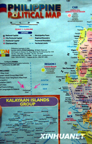
The Philippine territory is set by a series of international treaties, no of which involves Huangyan Island. The Treaty of Paris(1898), The Treaty of Washington(1900) and the Treaty with Great Britain (1930) state clearly that west limit of the Philippines territory is 118th degree meridian of longitude east of Greenwich, while the Huangyan Island is obviously outside this limits(15°08'-15°14'N, 117° 44'-117°48'E). The 1935 Constitution of the Republic of the Philippines, the 1946 Treaty of General Relations between the United States of America and the Republic of the Philippinesthe, the 1952 U.S.-Philippines Mutual Defense Treaty, the 1961 Repbulic Act No.3046 and the 1968 Republic Act. No. 5446 have reaffirmed the legal effects of the above-mentioned three treaties and once again expressively defined the Philippine territorial limits, the baseline points and baseline of the territorial waters, which have not included the Huangyan Island. The Philippine maps published in 1981 and 1984 also indicate that Huangyan is outside the Philippine territorial limits. The above facts fully prove that Huangyan Island is outside the scope of Philippine territory.
Until 1997, the Philippines has never put dispute on China's juristiction and development on Huangyan Island, while it repeatedly stated that the Huangyan Island was outside the Philippine territory. Then Philippine Ambassador to Germany indicated clearly in his letter to a Gernmany radio amateur on 5 February of 1990 that, the Huangyan Island was not within the Philippine territorial and sovereignty according to the National Mapping and Resource Information Authority of the Philippines. The documents issued by the National Mapping and Resource Information Authority of the Philippines to the American Radio Relay League on 18 October and 18 November 1994 have also confirmed respectively that the Philippine territorial limits and sovereignty was stipulated in the Paragraph 3 of the Treaty of Paris of 1989 and Huangyan Island was outside of the Philippine territory boundaries.
It is the basic principle of the international maritime lawn that land rules water. UNCLOS allows coastal states to claim a 200-nautical-mile exclusive economic zone (EEZ), but coastal states have no rights to harm the inherent territory and sovereignty of other countries. Any attempt to change the ownership of the territorial sovereignty by UNCLOS is a violation of the principles of international laws, including that of UNCLOS, and will never be realized. The maritime jurisdiction scope of the Philippines should not harm the territorial sovereignty of China over the Huangyan Island.
-------------------------------------------------------------------------------------------------------------------------------
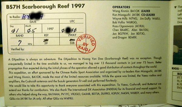
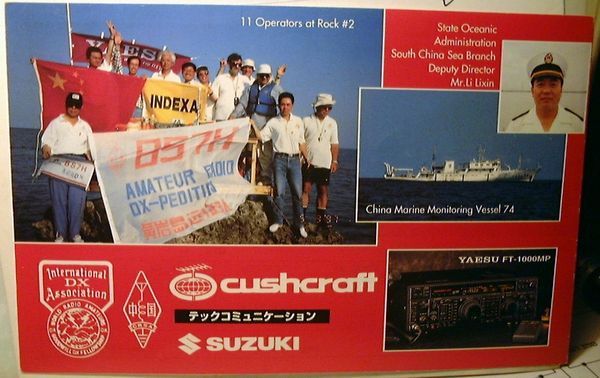
DX Century Club
DXCC - BS7H


No comments:
Post a Comment